
Dynamics of a retreating ice sheet : a LiDAR study in Värmland, SW Sweden
Author
Summary, in English
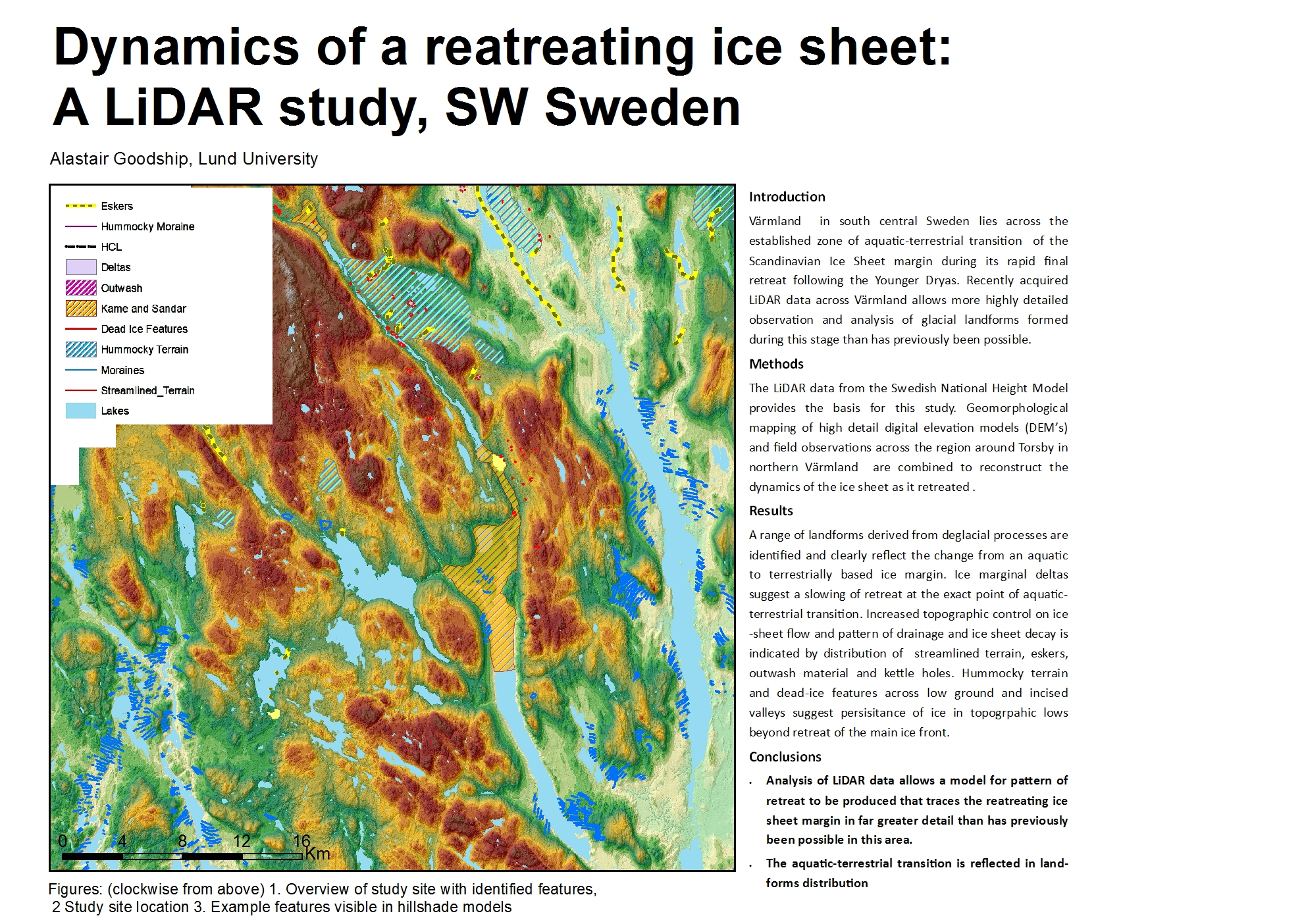
Värmland in south central Sweden lies across the established zone of aquatic-terrestrial transition of the Scandinavian Ice Sheet margin during its rapid final retreat following the Younger Dryas. Recently acquired LiDAR data across Värmland allows more highly detailed observation and analysis of glacial landforms formed during this stage than has previously been possible. This study synthesises geomorphological mapping of highly detailed digital elevation models (DEM’s) and field observations across the region around Torsby in northern Värmland to reconstruct the dynamics of the ice sheet as it retreated. A range of landforms derived from deglacial processes are identified and clearly reflect the change from an aquatic to terrestrially based ice margin. Ice marginal deltas suggest a slowing of retreat at the exact point of aquatic-terrestrial transition. Increased topographic control on ice-sheet flow and pattern of drainage and ice sheet decay is indicated by distribution of streamlined terrain, eskers, outwash material and kettle holes. Hummocky terrain and dead-ice features across low ground and incised valleys suggest persisitance of ice in topogrpahic lows beyond retreat of the main ice front. Combined analysis of identified landforms allows a model for pattern of retreat to be produced that traces the retreating ice sheet margin in far greater detail than has previously been possible in this area.
Summary, in English
The retreat of the world's major ice sheets is a key area of study for current climate research. However, when the last major retreat of ice sheets happened there was no-one around to record how and why it occurred. The answers to this previous retreat lie within the geological deposits and landforms left behind. Through study of these features it is possible to improve our knowledge and predictions for how the Antarctic and Greenland ice sheets will retreat in the coming years and decades. This paper looks at how the high resolution imaging provided by LiDAR surveying, allows a model of retreat for the margin of an extinct ice sheet to be created at greater detail than previously possible.
Department/s
Publishing year
2017
Language
English
Publication/Series
Dissertations in Geology at Lund University
Full text
- Available as PDF - 15 MB
- Download statistics
Document type
Student publication for Master's degree (two years)
Topic
- Earth and Environmental Sciences
Keywords
- LiDAR
- SIS
- retreat
- deglacial
- DEM
- geomorphology
- Värmland
Report number
500
Supervisor
- Helena Alexanderson (professor)
Scientific presentation