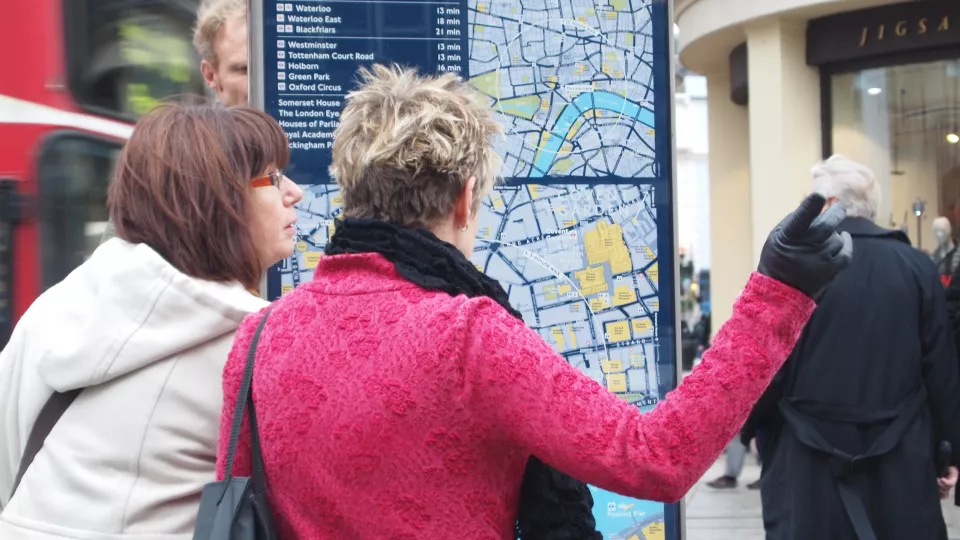
A challenge for big cities today is that there are too many vehicles, which creates both traffic and pollution. Through different initiatives, people are being encouraged to walk more. In addition to improving footpaths, walking paths and lighting, authorities have also recognised the importance of how information about navigating on foot is conveyed to ensure residents view walking as an attractive alternative.
Tens of thousands of sample maps required
All maps are simplified images of reality. They look different depending on how they are meant to help us interpret different environments or to find a particular location. Understanding how maps are designed and how people search for information is a specialist skill. There are many publications and rules about how different kinds of symbols and geographical data should relate to each other. Maps can include many different layers of information and, for example, by using different colours, shapes, or sizes, they can describe how important each item is or what they represent.
“One of the challenges of current map production is the fact that the placement of icons, texts and the like is done manually to a large degree, which is very costly”, explains Lars Harrie, and continues: “We want to research how artificial intelligence, AI, can provide us with new knowledge and contribute to innovation and reduced production costs.”
Rachid Oucheikh, a postdoc in machine learning, is working on the project using several new methods to study how data-driven work methods can generate improvements and simplifications. It requires tens of thousands of maps to be uploaded and analysed with the aim to train an AI network to recognise the best icon and text placement.
We hope to contribute to new open tools that can be used by many
“We are going to tackle the problem using several methods. The first one we are working is image-to-image translation and aims to learn mapping from a source domain of non-labelled maps to a target domain of labelled maps”, explains Rachid Oucheikh. “We will then compare this to another method based on identifying the most important key positions on a map.”
A third method is based on image composition which, via machine learning, learns the hidden characteristics and structures of map images with regard to text and icon placement. This method will be evaluated at the end of the project’s first year. Following this, the most suitable method will be chosen for further development in the second year.
Real life test data
One of the biggest challenges in machine learning in cartography is to gain access to sufficient map data. Since maps are everywhere and digitalisation has been underway for a long time, one might think this would not be a problem. However, map data from authorities and private companies usually have user licences that do not allow for large-scale machine learning studies.
“Map data exists but it is often not public or accessible. Therefore we are so happy about our collaboration with T-Kartor, a company that works with many big city clients, and through them we are now able to carry out testing with real data”, explains Lars Harrie.
The Swedish company T-Kartor originated in Skåne but operates on a global level and, among other things, they create city wayfinding maps for big cities such as New York, London and Paris. The collaboration between the company and the researchers is valuable for both parties. T-kartor gains access to cartographic knowledge and methods that can lead to innovation of new advanced geographical products. The researchers gain a better understanding of practical applications and different issues that must be addressed in real life.
Tacit knowledge is heard
During the two years in which Rachid Oucheikh will be working on the project, there will not be time to develop practical applications from the theories. However, in the long term, it is valuable to be able to use new technology for the development of maps. The City of London, for example, has a 100-page document on all the rules regulating map design with different instructions based on many user tests. Experienced cartographers often intuitively have this form of tacit knowledge, but it is difficult to translate it into formalised knowledge. Machine learning can provide answers by studying large quantities of well-made maps.
“We often obtain what we refer to as tacit knowledge when using applied AI”, says Rachid Oucheikh, who has two previous postdoc positions under his belt, in Norway and in Jönköping, where he specialised in self-driving vehicles.
Information management in city maps is quite an unexplored field when it comes to the application of machine learning and the aim is to share the results and knowledge as open applications for others to use and refine.
“Even if we collaborate with a company, they are not the only ones to benefit from our project. We hope to contribute to new open tools that can be used by many and generally reduce costs”, concludes Lars Harrie.
An additional benefit is if better map information leads to a reduction in climate impact when more people choose to walk in big cities thanks to better wayfinding.